












The Spatial Answer Engine · PT Geo Inovasi Nusantara

The Right Data
For Every Location!

GeoSquare is a leading geospatial solutions provider deliveringsimplified location insights that drive business clarity and growth.

the problem

Why Businesses Struggle
With Location Data

Most organizations face massive gaps when making spatial decisions.

01

Outdated & Unverified Data

Off-the-shelf maps miss local context, micro-POIs, land boundaries, and rapid urban developments — leaving businesses with a distorted picture of reality.

02

Data Silos & Complexity

Spatial data requires specialized GIS expertise, multi-vendor tools, and complex data formatting. Most teams can't act on it without a dedicated analyst.

03

High Cost of Field Collection

Manual ground surveys are slow, expensive, and difficult to scale across nationwide footprints — making continuous data refresh practically impossible.

04

The Actionability Gap

Map visuals are nice, but business leaders need answers: "Where should we expand?", "What is the site score?", "What is our true market coverage?"

the solution

From Ground Truth
To Intelligence

A full-stack spatial platform combining field survey execution with AI analytics — turning raw geographic data into actionable business answers.

Field Ops
01

Field Data Collection

Drones, LiDAR, ground mobile app, custom POI surveys, land parcel verification — executed by our own survey team across Indonesia.

QA & Processing
02

Data Processing & QA

Automated cleaning, deduplication, geo-referencing, and AI quality scoring to ensure every data point meets enterprise-grade standards.

Spatial AI
03

Spatial AI Engine

Predictive scoring, cannibalization modeling, catchment area analysis, and demand index — powered by GeoBrain, our proprietary AI engine.

Activation
04

Business Activation

Web GIS dashboards, API integration, custom spatial reports, and shapefile/GeoJSON exports — ready to plug into your existing workflows.

Better data → Better models → Faster decisions

Location Intelligence Core

OUR CORE CAPABILITIES

Instead of offering disconnected geospatial services, GeoSquare focuses on two fundamental Location Intelligence capabilities.

CAPABILITY // 01KNOW YOUR LOCATION

Location Profile

“What does this location look like?”

A Location Profile answers the fundamental question of understanding site context, surrounding territory dynamics, and environmental indicators before committing capital.

Useful for understanding:
  • Land assets
  • Existing branches or outlets
  • Potential development sites
  • Investment locations
  • Market environments
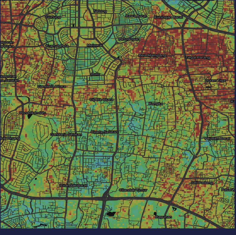
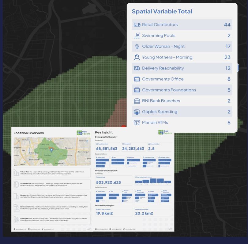
GeoSquare Location Profile Spatial Variables Map
Depending on objective, includes:
• Surrounding POIs• Commercial activity• Multi-modal accessibility• Road infrastructure• Settlement patterns• Land & environmental• Mobility patterns• Competitor footprint
Status: In Production
CAPABILITY // 02FIND THE RIGHT LOCATION

Location Scoring

“Which location should we choose?”

Location Scoring helps organizations compare and evaluate multiple candidate locations using a structured, data-driven framework with comparative ranking.

This capability supports:
  • Site Selection
  • Branch expansion
  • Outlet expansion
  • Land prioritization
  • Market expansion
  • Investment decisions
  • Location benchmarking
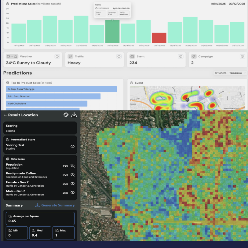
GeoSquare Location Scoring Relative Heatmap
Scoring & Prioritization Framework:

Locations are systematically evaluated, weighted across customizable business criteria, ranked, and prioritized based on their relative commercial potential and cannibalization radius.

Status: In Production
Interactive Testbed

Try The Live Intelligence Engines

Switch between the AI Location Profiler copilot and the multi-variable Location Scoring inspector below.

AI LOCATION PROFILER // KNOW YOUR LOCATION
DEMO CHAT: 0/3
GeoSquareChat AI
Service History
Today
GeoSquare OS v2.4PRO
Geospatial AI Copilot for Decision Makers

Tanyakan apapun tentang lokasi, kompetitor, dan potensi pasar

Pilih salah satu modul analisis di bawah atau ketik lokasi yang ingin Anda evaluasi:

Powered by GeoSquare 50m Spatial Mesh Engine · Indonesia Coverage

End-to-End Value Chain

HOW GEOSQUARE WORKS

Dari triliunan sinyal pergerakan mentah hingga output dashboard dan feed siap konsumsi untuk pengambil keputusan.

Data Ingestion Feeds

Multi-stream mobility signals, satellite telemetry, national census, and 5.8M+ POIs across Indonesia.

Telco Mobility
Satellite 0.5m
BPS Census
5.8M Storefronts

GeoSquare 50m Engine

Sub-block spatial mesh aggregation, differential privacy, daypart velocity, and ML catchment modeling.

50m Grid Mesh
k-Anonymity (UU PDP)
Isochrone AI
Catchment Polygon

Delivery & Execution Formats

Turnkey enterprise interfaces matching whatever stack your organization operates.

Ready Datasets (Parquet)
Interactive Web GIS
Board Feasibility Reports
REST APIs
machine scale

Modelling Indonesia At Machine Scale

50m× 50m

Spatial Grid Precision

Sub-block resolution that differentiates neighboring storefronts and land parcels with unmatched accuracy.

5.8M+POIs

Verified Locations Indexed

The most complete commercial directory in Indonesia, with demographics, visitor density, and competitor analysis.

17,508Islands

Full Archipelago Coverage

From metropolitan Tier 1 cities to remote Tier 4 territories — no blind spots across Nusantara.

< 50msLatency

Real-Time API Response

Multi-region infrastructure in Jakarta delivering ultra-low latency spatial intelligence at any scale.

core products

OUR PRODUCTS

Three enterprise spatial intelligence engines engineered for precision land, commercial growth, and risk mitigation.

PROD // 01land intelligence

Land Intelligence Platform

Manage and optimize land assets with integrated spatial intelligence. Assess land portfolio health, generate location profiles, and evaluate development potential at any site across Indonesia.

Land Portfolio Management
Location Profile & Scoring
Land Potential Assessment
Explore Product
PROD // 02business analytics

Business & Financial Insights

Quantify market potential, benchmark outlet performance, and evaluate accessibility to maximize commercial success. Built for retail expansion, banking, and financial services.

Market Potential Analysis
Outlet Performance Benchmarking
Accessibility & Catchment Modeling
Explore Product
PROD // 03climate risk

GeoSquare Climate Risk Index

Assess climate hazard exposure and location risk at any site in Indonesia. Quantify flood, subsidence, and natural disaster risk for investment, insurance, and infrastructure decisions.

Climate Hazard Exposure Mapping
Location Risk Assessment
ESG & Resilience Scoring
Explore Product
FROM INTELLIGENCE TO ACTION

FLEXIBLE DELIVERY OUTPUTS

GeoSquare delivers Location Intelligence through flexible outputs based on the needs of each organization — from executive PDF decks to programmatic API feeds.

Format 01
Executive Reports

Data & Insights Report

Clear and actionable reports that communicate the key findings behind a location or portfolio.

Reports may include:
Location characteristics & environmental context
Comparative analysis across potential sites
Objective location scoring results (0–100)
Opportunity identification & catchment gaps
Strategic go / no-go recommendations
Best For: Board, C-Level, Real Estate & Expansion TeamsRequest Sample
Format 02
Developer Integration

API-based

GeoSquare intelligence can also be integrated directly into client systems and digital platforms through APIs.

Key Capabilities:
Enables organizations to access Location Intelligence at machine scale
Incorporate spatial insights into existing CRM, ERP, and underwriting workflows
Real-time scoring endpoint with sub-50ms latency
Automated bulk data feeds to BigQuery, Snowflake, or S3 (GeoParquet)
100% compliant with Indonesian UU Perlindungan Data Pribadi (UU PDP)
Best For: Tech Teams, Banking Underwriting, Logistics ERPExplore API Docs

Enterprise SLA & Data Governance

All data is de-identified, verified by ground census, and hosted on sovereign Indonesian cloud infrastructure.

Consult Your Delivery Needs
urban use cases

BUSINESS INSIGHTS

Multi-layered spatial intelligence connecting ground demographics, mobility, environmental risks, and machine learning models for precise commercial decisions.

STEP // 01Ground & Spatial Context

Location Profile

Detailed information of the location, from foot traffic, commercial coverage, demography, and hazard analysis.

STEP // 02Human Expert + AI

Hybrid Modelling

Blends expert spatial knowledge with machine learning to connect multiple data layers, revealing patterns that matter.

STEP // 03Objective Valuation

Land Value Model

Turns those patterns into detailed land value estimates and viability scores, enriched by key influencing drivers.

9-Layer Geospatial Architecture

From Raw Geographic Layers to Quantified Land Value

HYBRID MODEL ACTIVE · 50M MESH
Tier 01 // Physical & Environmental
01. DemographyLAYER_01

Income strata, education levels, household purchasing power, and desirable demographic patterns.

02. Distance to CBDLAYER_02

Proximity to central commercial hubs, employment nodes, government centers, and arterial avenues.

03. Spatial ZonesLAYER_03

Official spatial zoning: residential, commercial, industrial, green belt, and mixed-use regulations.

Tier 02 // Urban Activity & Risk
04. Flood HazardLAYER_04

10-year hydrological flood return models, elevation, drainage capacity, and historical inundation risk.

05. People DensityLAYER_05

Day vs night mobility density, commuter footfall intensity, and active catchment population size.

06. ReachabilityLAYER_06

Transit isochrones to MRT, LRT, Commuter Line, toll gates, and primary multi-modal access routes.

Tier 03 // Valuation & Capitalization
07. AmenitiesLAYER_07

Clustering of F&B, supermarkets, healthcare facilities, schools, and essential lifestyle services.

08. Market ValueLAYER_08

Current transaction prices, listing comparables, and buyer-seller equilibrium at specific time windows.

09. Land Value (Output)OUTPUT

Final objective economic value per 50×50m grid, independent of building structures, calibrated by AI.

Spatial Synthesis: 9 Layers → 1 Standardized Land Value Index
Multi-Factor Fusion Machine Learning Calibrated
Execution Engines · Slide 9

Three Specialized Analytical Engines

Targeted AI workflows designed for expansion strategists, territory managers, and supply chain operators.

Machine Learning ExpansionMOD // 01

Personalized Expansion Model

Uses machine learning with thousands of spatial variables to identify key drivers of store success. Produces heat maps that highlight the best areas for future expansion based on feature importance.

Personalized Expansion Model
Site Viability RankingRequest Demo
Micro-Location ProfilerMOD // 02

Store Location Profile

Detailed information of the location, from traffic, coverage, demography, and hazard analysis. Enhanced with AI-generated reports offering tailored sales, delivery feasibility, and marketing strategies.

Store Location Profile
10+ Spatial VariablesRequest Demo
Dynamic Demand AIMOD // 03

Demand Forecasting & Alerts

Combines weather, traffic, event context, urban indicators, and historical sales data to forecast hourly outlet-level demand, giving operators proactive replenishment and staffing alerts.

Demand Forecasting & Alerts
Hourly Context & AlertsRequest Demo
urban use cases

GEOLAND VALUATION

Understand the value and quality of your location using objective and measurable spatial analytics methods. GeoLand produces 50×50 meter grids filled with multi-factor indicators to support rapid land assessment and appraisal.

geosquare-landvalue // subdistrict-pancoran
Live Spatial Model · 50m Precision
PROVINSI: DKI JAKARTA/KOTA: JAKARTA SELATAN/KECAMATAN: PANCORAN
VALUATION COMPLETE · 1,420 CELLS
GRID #PC-0842 · Rp 23.850.000 / m²
Land Value (IDR / m²)
> Rp 45.000.000
Rp 28M – Rp 45M
Rp 18.5M – Rp 28M
Rp 14.3M – Rp 18.5M
Land Score
8.1 / 10
Excellent Tier Area
Lower Bound Value
Rp 14.358.147
Per m² Base Benchmark
Estimated Land Value
Rp 18.501.481
Calibrated Market Median
Upper Bound Value
Rp 57.020.210
Arterial Corridor Peak
92%

Connectivity

Proximity and travel time to Train/KRL stations, MRT, LRT, and Toll Road arterial entrances.

88%

Livability

Zoning balance, green canopy ratio, pedestrian safety, and residential neighborhood stability.

94%

Vibrancy

F&B footfall density, commercial retail clustering, and diurnal visitor activity index.

Low Risk

Environmental Risks

Satellite-derived land subsidence rate, 10-year flood hazard return periods, and soil stability.

Need Objective Land Valuation for Your Portfolio?

Available as custom advisory reports or programmatic API feeds across Jakarta and all major Indonesian metropolitan corridors.

Request Valuation Sample
URBAN USE CASES • AUTOMATED CREDIT DECISIONING

GEOSQUARE LAND VALUE VIA API

Eliminate weeks of manual appraisal turnaround. Banks and multi-finance lenders automatically trigger GeoSquare spatial scoring APIs at loan origination to evaluate prospective debtors in milliseconds.

Loan Proposal File
#DEB-2026-0482
Prospective Borrower
Anton VemaleID VERIFIED
Home Address
Jalan Raya Tengah No. 20, Pasar Rebo, Jakarta Timur, DKI Jakarta
Business Address
Jalan Raya Condet No 21, Condet, Jakarta Timur, DKI Jakarta
Requested AmountRp 750.000.000
Collateral TypeSHM No. 04821
STATUS: SUBMITTED
GeoSquare.ai API Integration
GET/Retrieve Data/instant
type: "Business Vitality", address: business address
Business Vitality Insight
Example: (3, "Favorable")
SCORE: 3 / 4
GET/Retrieve Data/instant
type: "Land Scoring", address: home address
Land Scoring Insight
Example: (1, "Low")
RISK: LOW (1/5)
LATENCY: ~142msAUTHENTICATION: BEARER JWT
Credit Decision
Confident Underwriting
Client’s operations team is confident to decide: Approve or Reject instantly based on verified spatial parameters.
On-Demand Field VerificationOPTIONAL
/Create Order
"Store Survey", business address
Field Dispatch:GeoSquare Team
Callback:Webhook Result
INSTANT APPROVE DISPATCHED
ZERO HUMAN APPRAISAL DELAY
SECURITY: TLS 1.3 + OIDCUPTIME: 99.95% SLAGEO-COVERAGE: 514 KOTA/KABUPATEN
PROPERTY OF GEOSQUARE.AI • PRIVATE & CONFIDENTIAL
URBAN & RURAL USE CASES • ADVANCED SPATIAL INTELLIGENCE

GEOSPATIAL AI, DIGITAL TWIN, & GIS

Enhance your insights with Geospatial AI for: automatic data extractions for buildings, land covers, tree counting; digital twin & 3D modeling; and GIS & Remote Sensing analytics.

01 // Computer VisionAcc. > 96.4%

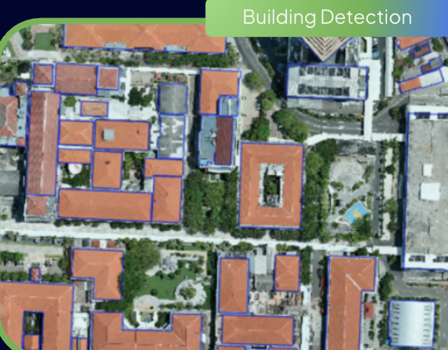
Building Detection

Building Detection

Automated deep-learning segmentation of building footprints, roof typology, and perimeter dimensions from high-resolution satellite and aerial ortho-imagery.

READY VIA API
02 // Remote Sensing10+ Classes

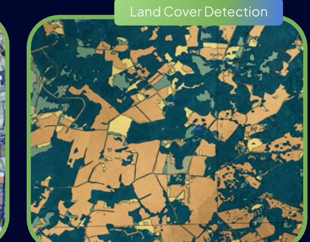
Land Cover Detection

Land Cover Detection

Multi-temporal classification of land surface changes: vegetation vigor, built-up surfaces, water bodies, and agricultural plots for regional planning.

READY VIA API
03 // Computer VisionSingle-Crown AI

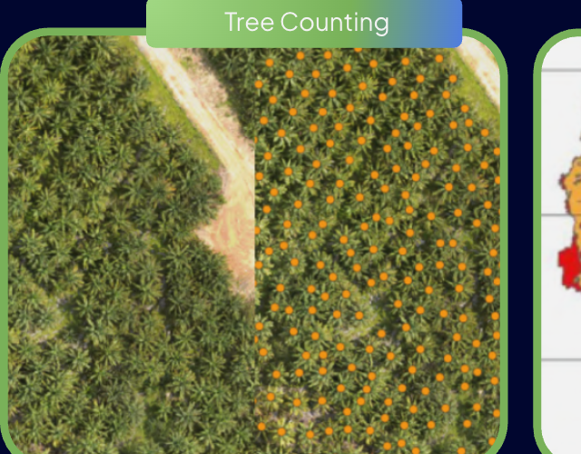
Tree Counting

Tree Counting

Automated crown detection and individual counting for oil palm, industrial timber (HTI), and agroforestry plantations with NDVI canopy vitality indexing.

READY VIA API
04 // Remote SensingMulti-Criteria

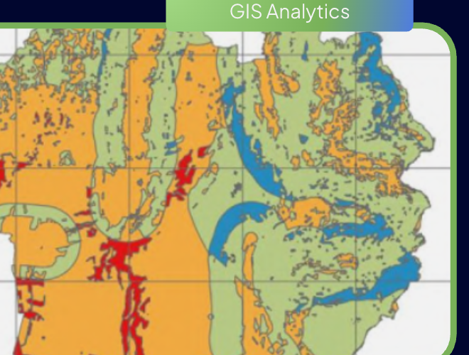
GIS Analytics

GIS Analytics

Advanced spatial statistical analysis: isochrone reachability modeling, kernel density estimation, and multi-criteria decision analysis (MCDA).

READY VIA API
05 // Remote SensingHydrological DEM

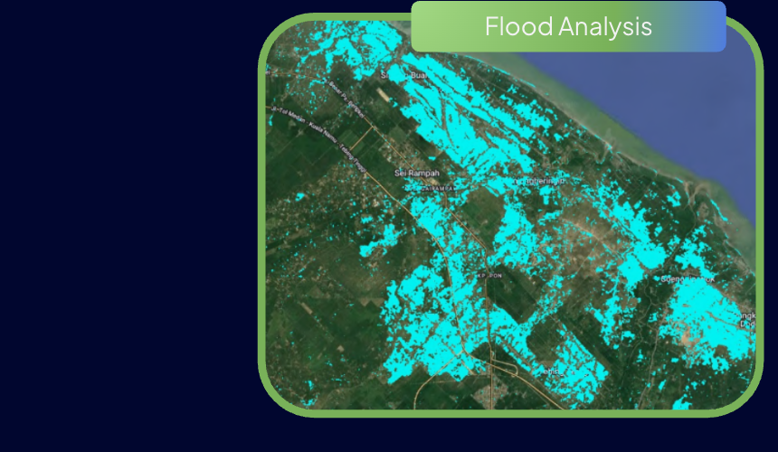
Flood Analysis

Flood Analysis

Hydrological runoff simulations combining high-precision Digital Elevation Models (DEM/DSM), historic satellite radar (SAR) inundation, and rainfall return periods.

READY VIA API
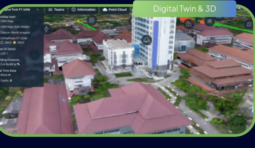
06 // 3D ModelingLoD2 / LiDAR Mesh

Digital Twin & 3D Modeling

Digital Twin & 3D Modeling

Millimeter-grade LiDAR point cloud processing, LoD2 3D building models, and textured 3D meshes for smart city governance and asset life-cycle management.

READY VIA API
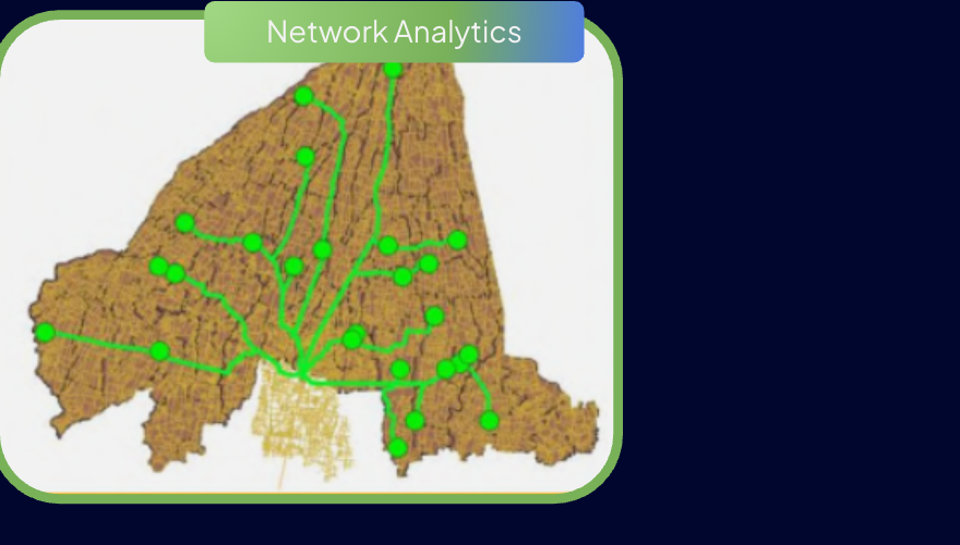
07 // Spatial NetworkGraph Routing

Network Analytics

Network Analytics

High-performance road network topology analysis, multi-depot vehicle routing optimization, and arterial supply chain bottleneck identification.

READY VIA API
All 7 Geospatial AI pipelines can be deployed on-premise, via GeoSquare Managed Cloud, or batch-processed via spatial webhooks.
EXPLORE AI API DOCS
RURAL USE CASES • SOVEREIGN LAND INTELLIGENCE

LAND SEARCH & EUDR INTELLIGENCE

Empowering national land banking (Badan Bank Tanah), corporate forestry, and industrial plantations with cadastre availability, biophysical suitability, and EUDR compliance audits.

PILLAR 01 // BANK TANAHCADASTRE

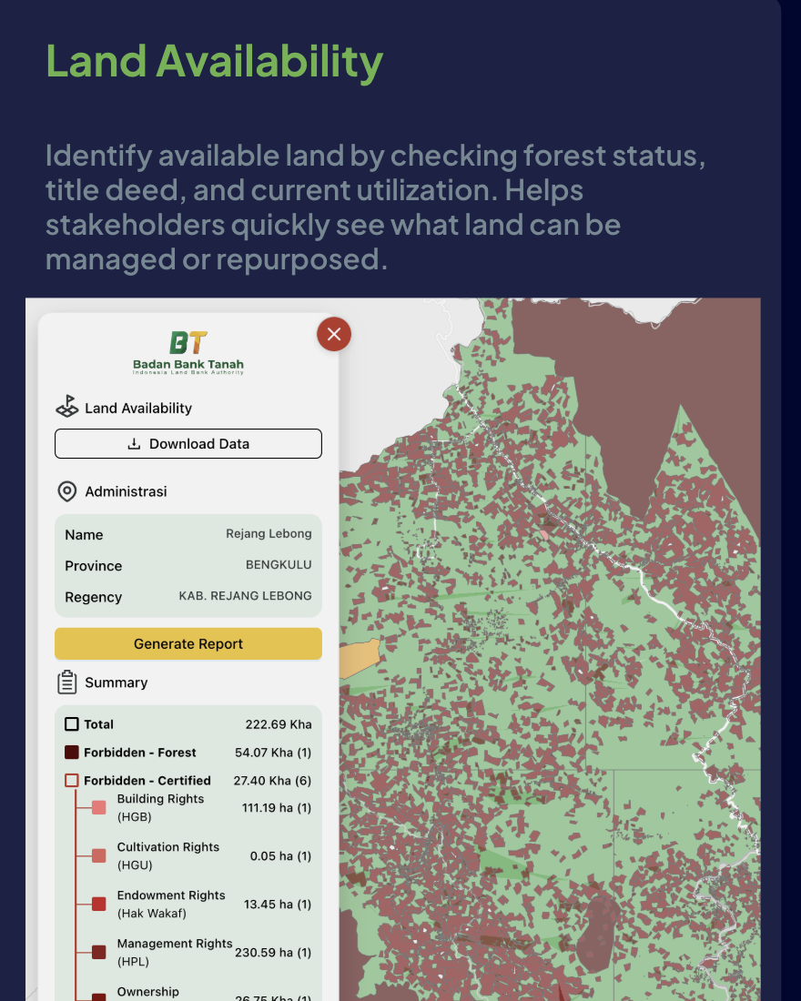
Land Availability

Identify available land by checking forest status, title deed, and current utilization. Helps stakeholders quickly see what land can be managed or repurposed.

Land Availability Badan Bank Tanah
Rejang Lebong, Bengkulu222.69 Kha
PILLAR 02 // SUITABILITYBIOPHYSICAL

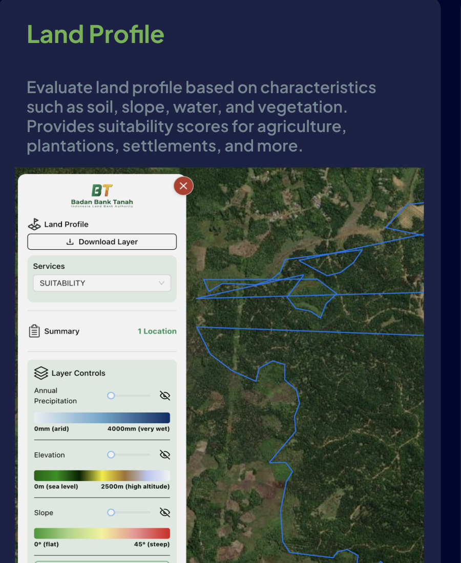
Land Profile

Evaluate land profile based on characteristics such as soil, slope, water, and vegetation. Provides suitability scores for agriculture, plantations, and settlements.

Land Profile Biometrics
Slope & Elevation LayersSUITABILITY 89%
PILLAR 03 // COMPLIANCEEUDR AUDIT

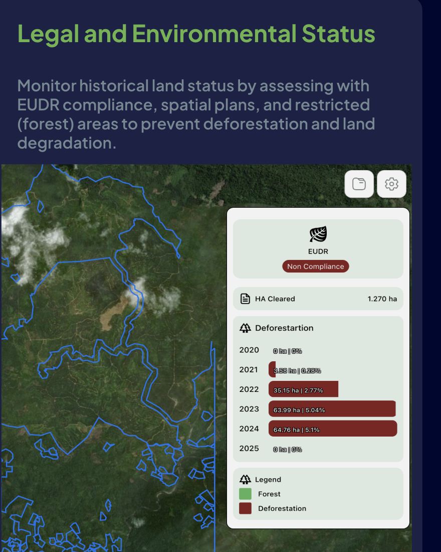
Legal & EUDR Status

Monitor historical land status by assessing with EUDR compliance, spatial plans, and restricted forest areas to prevent deforestation and land degradation.

EUDR Deforestation Compliance
Cleared Polygon Audit1.270 ha CLEARED
DETAILED BREAKDOWN //

Badan Bank Tanah Cadastral Availability (Rejang Lebong, Bengkulu)

TOTAL: 222.69 Kha
Zoning & Right CategoryCoverage / Count
Forbidden - Forest54.07 Kha (1)
Forbidden - Certified27.40 Kha (6)
Building Rights (HGB)111.19 ha (1)
Cultivation Rights (HGU)680.4 ha (1)
Management Rights (HPL)230.59 ha (1)
Ownership (Hak Milik)1.450,6 ha
Bank Tanah Map Rejang Lebong
RURAL USE CASES • RENEWABLE ENERGY INFRASTRUCTURE

SOLAR PANEL SITE SUITABILITY

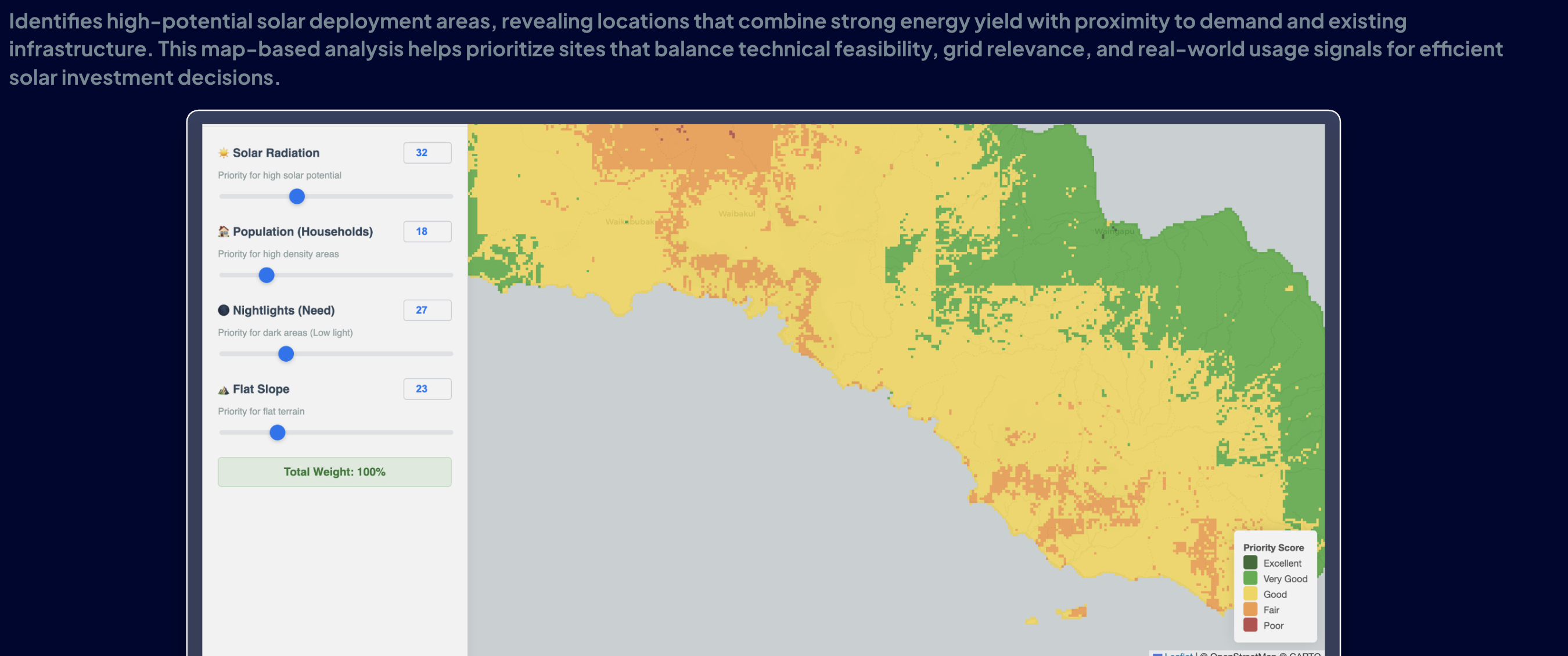
Identifies high-potential solar deployment areas, revealing locations that combine strong energy yield with proximity to demand and existing infrastructure. This map-based analysis helps prioritize sites that balance technical feasibility, grid relevance, and real-world usage signals for efficient solar investment decisions.

PLTS Suitability Heatmap (CARTO / OpenStreetMap Basemap)INDONESIA REGIONAL GRID
Solar Panel Site Suitability Map
Priority Score: Excellent Very Good Good Poor
© OpenStreetMap © CARTO
4 Core Analysis LayersALL ACTIVE
Solar RadiationGHI > 4.8
Global Horizontal Irradiance yield modeling per km².
Population (Households)DEMAND
Proximity to rural grid consumption nodes and households.
Nightlights (Need)ELECTRIFICATION
VIIRS satellite radiance measuring underserved communities.
Flat SlopeSLOPE < 5°
Digital Elevation Model (DEM) slope to reduce civil earthwork cost.
IPP & UTILITY BENEFIT
Accelerate Solar Farm Bankability

GeoSquare eliminates speculative land scouting, cutting feasibility study lead times from 6 months down to under 48 hours.

REQUEST PLTS FEASIBILITY REPORT
use cases

SOLUTIONS BY INDUSTRY

Specialized spatial analytics tailored to the unique operational and capital requirements of leading enterprises and institutions.

+35% Store ROI
High Footfall Hubs

Retail & FMCG Expansion

Find the Right Location. Expand with Confidence.

Identify the highest-potential sites for new branches, outlets, or dark stores. Model catchment footfall, benchmark competitors, and eliminate cannibalization before signing leases.

Catchment & Footfall Modeling
Competitor Proximity Benchmarking
Cannibalization Risk Scoring
50m Mesh ResolutionConsult Solution
Sub-50ms Underwriting
Fintech & Banking

Banking & Financial Services

Spatial Credit Scoring & Collateral Valuation

Empower credit underwriting and mortgage appraisal with objective spatial intelligence. Map branch and ATM performance, identify unbanked pockets, and benchmark land collateral value.

Collateral Land Valuation
Location-Based Credit Scoring
Branch & ATM Network Optimization
50m Mesh ResolutionConsult Solution
92% Valuation Accuracy
CBD & Land Assets

Commercial Real Estate & Land

GeoLand Value — Objective, Data-Driven Land Pricing

Assess land value, development feasibility, and transit-oriented development (TOD) potential. Replace subjective appraisals with foot-traffic-calibrated spatial valuations.

Land Parcel Feasibility
Zoning & Permitting Verification
Yield & Rental Price Forecasting
50m Mesh ResolutionConsult Solution
Sub-cm LiDAR Accuracy
Infrastructure & BUMN

Energy, Utilities & Mining

Right-of-Way (ROW) & Asset Surveillance

Map utility corridors, transmission towers, renewable solar sites, and pipeline right-of-ways. Combine high-precision drone photogrammetry and LiDAR with ground asset monitoring.

Transmission ROW Corridor Mapping
Solar & Renewable Site Siting
Environmental & Hazard Monitoring
50m Mesh ResolutionConsult Solution
17,508 Islands Covered
Bapenda & Smart Cities

Government & Public Sector

Regional Tax Mapping (PBB-P2) & Urban Planning

Modernize municipal cadastral data, optimize local property tax (PBB-P2) revenues, and analyze urban mobility across all 17,508 Indonesian islands with verified spatial intelligence.

Cadastral Parcel & Tax Base Mapping
Urban Mobility & Public Transit Analytics
Disaster Risk & Hazard Mitigation
50m Mesh ResolutionConsult Solution
Flood & Subsidence Risk
Climate Resilience

Climate Risk & ESG Intelligence

GeoSquare Climate Risk Index (GCRI)

Quantify climate hazard exposure — flood frequency, land subsidence, and natural disaster vulnerability — at any site across Indonesia. Essential for ESG reporting and underwriting.

Flood Hazard Return Period Modeling
Land Subsidence Satellite Telemetry
ESG & TCFD Spatial Reporting
50m Mesh ResolutionConsult Solution

TRUSTED BY LEADING ENTERPRISES IN INDONESIA

Badan Bank Tanah
PT Bukit Asam
Grab
Barraslogi
Almaz
BRI
IDSurvey
Bapenda Jakarta

SUPPORTED BY GLOBAL ACCELERATORS & INDONESIAN SPATIAL ECOSYSTEM

Google for Startups
NVIDIA Inception
ANTLER
Mobilewalla
Kementerian ATR/BPN
Universitas Gadjah Mada (UGM)
Institut Teknologi Bandung (ITB)
MAPID
Colliers International
Locator Logic
Barraslogi
advisory services

SURVEY & MAPPING

Beyond analytics — GeoSquare operates its own field survey and geomatics capability across Indonesia. From drone flights to LiDAR scanning and ground POI census, we deliver verified spatial data where digital sources alone are insufficient.

Ground Truth

Ground POI Census & Verification

Systematic on-the-ground data collection to verify, update, and enrich point-of-interest (POI) records across any corridor or region in Indonesia. Ensures data accuracy where satellite imagery alone falls short.

OUTPUT:Verified POI Dataset + Building Attribute Enrichment
Aerial Survey

Aerial & Drone Surveying

High-resolution aerial imagery and orthophoto production using drone platforms. Ideal for land boundary mapping, construction progress monitoring, and large-scale site documentation.

OUTPUT:Orthophoto, DSM/DTM, and High-Res Imagery Output
3D Scanning

3D LiDAR Scanning

Precision 3D point cloud capture of buildings, infrastructure, and terrain using terrestrial and mobile LiDAR systems. Used for BIM, asset management, and structural analysis.

OUTPUT:3D Point Cloud, BIM-Ready Models & Structural Reports
Custom GIS

Mobile & Custom GIS Data Collection

Tailored field survey programs using mobile GIS platforms for rapid, scalable data collection. From socioeconomic surveys to infrastructure inventories — deployed nationwide.

OUTPUT:Structured Geospatial Dataset & Interactive Dashboard
Business Enhancement // Reusable Layer

Reusable Spatial Layer Across Multiple Decisions

The same verified geographic database powers strategy, daily operations, and long-term asset monitoring without redundant field surveys.

Better Data → Better Models → Faster Decisions
01 // Strategy

Expansion & Site Selection

Discover high-opportunity market gaps and benchmark competitor white spaces before capital commitment.

02 // Operations

Coverage & Service Planning

Identify underserved areas based on true spatial population demand and network infrastructure.

03 // Market Intel

Competitor Intelligence

Track commercial category density, competitor footprint growth, and brand penetration over time.

04 // Governance

Asset & Facility Inventory

Maintain a single verified, georeferenced master asset registry for auditing and operational agility.

developer infrastructure

REST API & DATA FEEDS

Akses seluruh data spasial mikro, catchment poligon, dan skor kelayakan lokasi secara instan lewat REST API dan SDK resmi berlatensi rendah.

Sub-50ms Execution Time

Multi-region lokal di Jakarta untuk respon real-time pada aplikasi mobile, website, maupun scoring kredit.

Enterprise Token & UU PDP

Granular API tokens, IP allowlisting, dan 100% data de-identification sesuai regulasi privasi nasional.

BigQuery & Snowflake Feeds

Ekspor berkala dalam format GeoParquet untuk dihubungkan langsung ke data pipeline internal Anda.

request.sh
curl -X POST "https://api.geosquare.ai/v1/spatial/score" \
  -H "Authorization: Bearer gsq_live_94f8a29b4e" \
  -H "Content-Type: application/json" \
  -d '{
    "coordinates": { "lat": -6.2088, "lng": 106.8456 },
    "resolution": "50m",
    "metrics": ["foot_traffic", "affluence_index", "catchment_polygon"]
  }'
API OPERATIONAL · 99.99% UPTIMEREST v1.4 · HTTPS
Frequently Asked Questions

FAQ & METHODOLOGY

Semua hal mendasar mengenai akurasi, metodologi spasial, dan kepatuhan privasi GeoSquare.

Location Profile answers "What does this location look like?" — it gives you a comprehensive picture of a site: surrounding POIs, accessibility, demographics, competitor landscape, mobility patterns, and environmental characteristics. Location Scoring answers "Which location should we choose?" — it compares and ranks multiple candidate sites using a structured, data-driven scoring framework so you can prioritize expansion with confidence.
insights & research

PUBLICATIONS & RESEARCH

Riset empiris mendalam, studi kasus pergerakan ritel, dan panduan analitik spasial terkini untuk para pengambil keputusan korporasi.

enter the future

Others build platforms.
We build the brain.

Schedule a confidential consultation with our spatial data team or request sample reports to evaluate precision location intelligence first-hand.

Legal EntityPT Geo Inovasi Nusantara
Direct Inquiriescontact@geosquare.ai
HeadquartersJakarta, Indonesia